🌍 Adventure Awaits: Navigate the world with confidence!
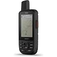
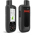
The Garmin GPSMAP 67i is a rugged handheld GPS device equipped with inReach® satellite technology, offering two-way messaging, interactive SOS capabilities, and access to preloaded TopoActive maps. With a large 3-inch sunlight-readable display, it ensures easy navigation in any environment. The device boasts an impressive battery life of up to 165 hours, making it perfect for extended outdoor adventures. Compatible with both iPhone and Android, it allows users to stay connected and informed while exploring the great outdoors.


| Memory Storage Capacity | 16 GB |
| Display Type | Transflective Color TFT |
| Human-Interface Input | Buttons |
| Compatible Devices | iPhone, Android |
| Are Batteries Included | Yes |
| Supported Satellite Navigation System | GPS |
| Connectivity Protocol | Bluetooth, Wi-Fi |
| Sport Type | Camping & Hiking, Outdoor Lifestyle |
| Battery Average Life | 165 Hours |
| Mount Type | Wrist Mount |
| Resolution | 240 x 400 |
| Screen Size | 3 Inches |
| Additional Features | Bluetooth |
| Connectivity Technology | Bluetooth, USB |
| Map Types | North America |
| Item Weight | 8.1 Ounces |
| Item Dimensions L x W x H | 2.5"L x 1.4"W x 6.4"H |
S**Y
Reliable and Feature-Packed GPS Device
I’ve been using the Garmin products for a while now, and they've proven to be a highly reliable GPS manufacturer.Pros:The GPSMAP 67 offers extremely accurate tracking and navigation. It quickly locks onto satellite signals, even in dense forests or remote areas, providing consistent and reliable location data.It comes preloaded with detailed maps, and the ability to add more maps is a huge plus. This is perfect for outdoor enthusiasts who need various types of terrain maps at their fingertips.One of the standout features is its impressive battery life. It can last for several days on a single charge when used intermittently, which is ideal for multi-day trips.The device feels robust and well-built. It’s waterproof, impact-resistant, and designed to withstand harsh outdoor conditions.The GPSMAP 67 includes a variety of helpful tools such as an altimeter, barometer, and compass. These are great additions for those who need more than just GPS for navigation.Cons:While the device is packed with features, there’s a bit of a learning curve to fully utilize them. The interface could be a bit more user-friendly, especially for beginners.It’s on the expensive side, but given the level of functionality and durability, I think it’s worth the investment if you spend a lot of time outdoors.Overall, the Garmin GPSMAP 67 is a top-tier GPS device for serious adventurers. It combines accuracy, durability, and long battery life in one package, making it a reliable companion for all outdoor expeditions. Highly recommended for hikers, explorers, and anyone needing precise navigation in rugged environments!
I**B
Best hiking GPS created.
First - This thing is fantastic. I've not needed to use the inreach feature yet but I used to carry a 66ST and an inreach mini. Having the 2 combined is fantastic. Map abilities are amazing. Screen resolution is very good. Not as high as an iPhone but it's very purpose built so it's great for navigation and assessment. GPS accuracy is remarkable with the multi-band GPS. Most of the time, you only need GPS.Battery life is unbelievable. I've always had the 8-15 hours on 2 AA or rechargeable. To have a battery that lasts 4-5 days makes it so even if you forget to turn it off, you will rarely be in situations where it renders you inoperable. Also, you don't need to carry extra batteries or charger unless you are on a longer adventure.The "down" side (not really). The interface is so feature-packed that it does have a learning curve. Once you have it, it is cake to use. It works wonderfully with Garmin Explore. You can download your favorite track from Alltrails or other sites and import them into collections. They sync via your iphone or laptop effortlessly (setting up phone connection can have some issues but is a set and forget thing).Overall, this thing is rugged beast that covers a fantastic range of functionality. TheHikingGuy indicated he doesn't need it because of his Garmin watch of which I have one. It is so much nicer to have a handheld that has a bigger screen for map reading and orientation without needing to unfold a map unless absolutely necessary. If you are a serious hiker, you are probably carrying a satellite device anyways and this thing is so worth adding a couple ounces of weight in my opinion.If you are thinking about it and have the budget - Go for it!
D**.
Great Addition to Our Camping Gear
My family loves to camp and hike. As we have begun doing some longer trails, and, in particular trails that are less traveled, it was important to us to be able to call for help, if needed, and to better understand where we were. There is a bit of a learning curve, but there are tons of YouTube videos that make learning this unit manageable. It is easy to add waypoints, track hikes, and send messages. It also provides peace of mind in case of emergency (btw, a subscription is needed for some of the features). We are very happy with our Garmin 67i and would recommend it to anyone looking for a portable and highly functional GPS unit.
T**L
It works and seems to be well made.
Very good product but not the most intuitive or that easy to use. Saying this, it’s probably the best handheld navigation device out there.
G**C
Bulky and expensive, but reliable!
A bit large and heavy for backpacking, but it's rugged and the battery last for days. Compared to a smartphone, well, there is no comparison. When everyone else's fingers are too wet or frozen to operate their smartphone touchscreen, its screen has cracked, or the battery has died, you will remember why you bought a real GPS / Satellite Communicator combo.Yes, the Garmin software ecosystem is complex and confusing. So practice before you go, and you'll be alight.
W**Y
Great GPS w/Fast Satellite Acquisition
Amazing GPS. I’ve had/used GPS devices since the last ‘80s. I wanted a new one with better satellites acquisition and this one does it. Fast startup, if the SD card isn’t stuffed with files, and can acquire satellites when indoors sitting near a window. My old ones couldn’t do that. This might be the last handheld GPS since todays cell phones can support these functionality and tomorrow’s phones will be satellite enabled. With satellite communication/terrestrial cell capabilities one will no longer need dedicated GPS devices even while out in very remote parts of the world. I did not go with the “67i” version because of the monthly fees and the fact that Starlink is now enabling emergency cellphone comes via their satellites.
Trustpilot
2 days ago
1 day ago